



GDE-067 |
Satellite image verification | |||||||
Geospatial and satellite | ||||||||
October 2026 | ||||||||
01
What it is
Satellite images are photographs of the Earth’s surface captured by orbiting sensors, and in OSINT they are dated evidence of what stood at a place at a given time. Free archives let you find imagery for almost any location and check a published satellite image against an independent capture.
Public satellite imagery comes in two broad kinds. Free government missions such as Sentinel-2 and Landsat revisit every location on a fixed schedule at moderate resolution, while commercial operators such as Planet and Vantor, formerly Maxar Intelligence, sell sharper images from their archives or on request.
The practical questions are when a place changed, what an image can and cannot resolve, and whether a satellite image published with a news claim matches independent imagery for the same date.
| When to use this guide
|
02
How do you find and verify satellite images of a place?
Six tools and seven steps take you from a claim to a dated, independently sourced image sequence.
Five of the six tools are free to use. SkyFi and EarthExplorer downloads need registration, and Copernicus Browser asks for a free account only for advanced features.
Google Earth: Free, no login, on the web or as the desktop app Google Earth Pro. Both show an imagery date for the view, and a Historical imagery control shows earlier captures.
World Imagery Wayback: Free, no login. Esri’s archive of every published version of its World Imagery basemap since February 2014, with a metadata layer showing capture dates.
NASA Worldview: Free, no login. Browses more than 1,000 global satellite imagery layers, many within three hours of observation. Coarse resolution, but daily coverage.
Copernicus Browser: Free, no login needed to browse, with a free account for advanced features such as timelapse and analytical download. Search and view Sentinel-1 radar and Sentinel-2 optical imagery by date and cloud cover. The Sentinel-2 archive runs from 2015 at up to 10-metre resolution.
USGS EarthExplorer: Free, registration needed to download. Searches the Landsat archive, which reaches back to 1972.
SkyFi: Free account, paid imagery. A marketplace for commercial archive images and new captures from multiple providers.
| Before you begin Stop at the login. Google Earth, World Imagery Wayback, NASA Worldview and Copernicus Browser work without an account, though Copernicus Browser asks for a free one for advanced features. EarthExplorer downloads and SkyFi need registration, so use a dedicated research identity rather than a personal login. Legal considerations. Copernicus Sentinel data is free and open, but anything you publish from it must carry a notice such as “Contains modified Copernicus Sentinel data” followed by the year of the imagery you used. Google, Esri and commercial imagery carry their own licence terms, so check them before republishing. |
Record the caption, the credited provider, the claimed capture date and the location as precisely as the source allows.
Match roads, coastlines, field boundaries and building footprints in the published image to the Google Earth basemap. Record the latitude and longitude to at least five decimal places.
Read the imagery date Google Earth shows for the view before calling anything new, then use Historical imagery for earlier captures. Google imagery of Tal al-Sultan, Rafah, that went viral on Google Maps in late September 2026 shows an imagery date of 25 February 2026 in Google Earth Pro, seven months earlier. Where one image covers a wide area, the date shown can be the oldest in a range, so treat it as the start of a window. In Wayback, read the capture date from the metadata layer.
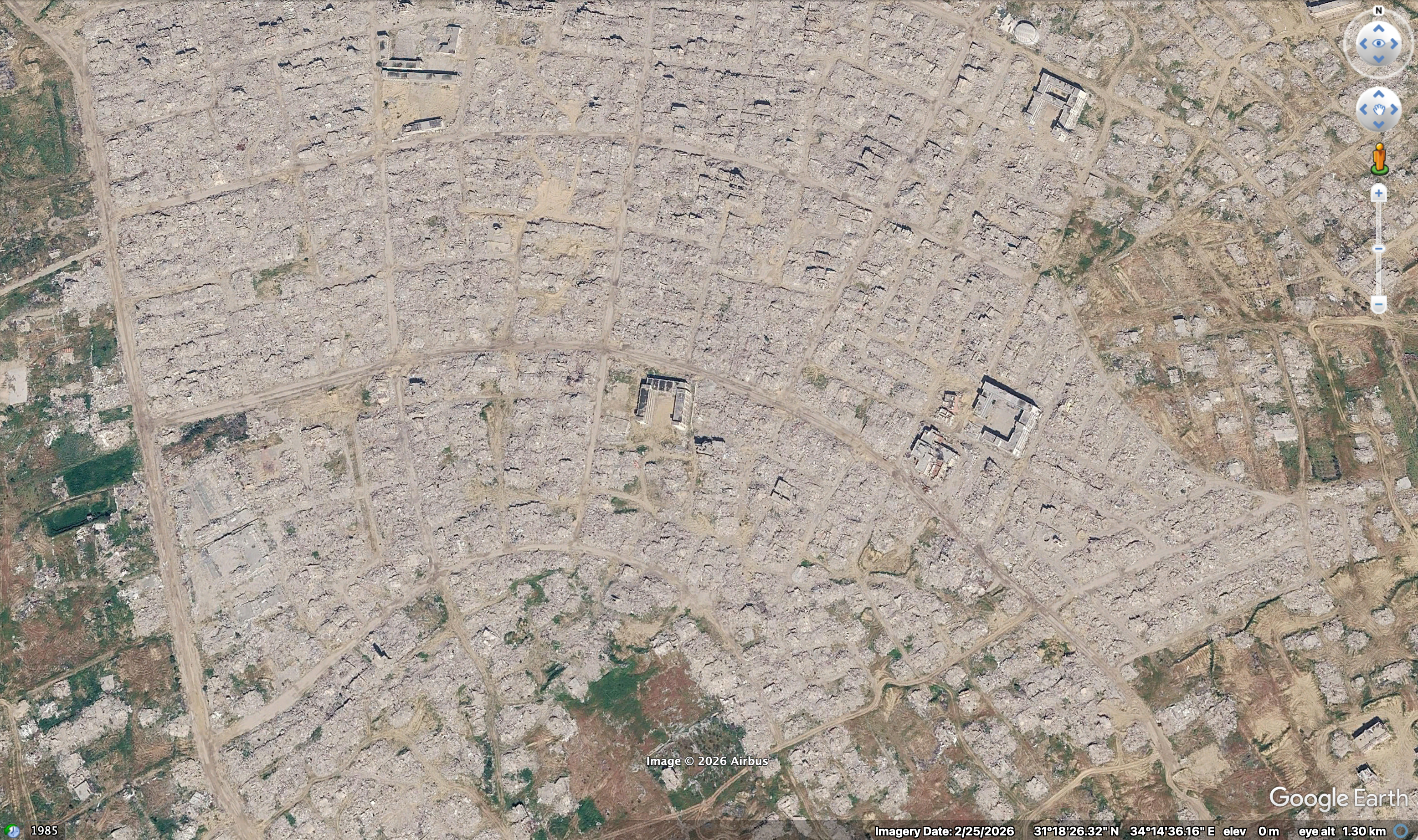
Tal al-Sultan, Rafah, in Google Earth Pro. Imagery date 25 February 2026, seven months before it went viral on Google Maps. Image © 2026 Airbus.
In Copernicus Browser, set the coordinates and a date range either side of the claim, filter by cloud cover and compare Sentinel-2 true-colour captures. Where cloud blocks the view, Sentinel-1 radar images the surface through cloud and darkness. For the Rafah tiles, a recent Sentinel-2 pass shows whether large-scale change has happened since February, and UNOSAT’s dated damage assessments give an independent reference.
Open NASA Worldview for the date and check cloud, smoke, flood extent and the fire layers. It cannot confirm small objects, but it can expose a clear-sky image dated to a day of thick cloud.
Use SunCalc to compare the sun’s direction at the site on the claimed date with the shadows in the image. Check the detail against the claimed sensor too: a 10-metre Sentinel-2 pixel cannot show individual vehicles, so an image that does came from a sharper source.
If free imagery cannot resolve the object, search the SkyFi archive for the date before paying for a new capture. Then write the verdict: which sources agree, the date range of the change and your confidence tier. For Rafah: captured 25 February 2026, not current; later change unassessed until a recent pass is checked.
|

03
Where satellite images mislead an investigation
Most errors come from reading a basemap, a pixel or a shadow as more precise than it is.
Basemap release date read as capture date: Google Earth and Esri basemaps are mosaics, and a version published this month can contain imagery captured years earlier. Verifying check: read the capture date for the exact coordinates from the Wayback metadata layer or the Google Earth historical imagery timeline.
Map pins read as ground truth: Labels for schools, mosques and parks stay pinned on the map after the buildings beneath them are gone, as on the Google imagery of Rafah that went viral in September 2026. A pin records that something was there, not that it still is. Verifying check: confirm every labelled site against the imagery itself and a dated damage assessment.
Cloud shadow read as a burn scar or damage: Dark patches from cloud shadow or harvested fields can resemble burn scars, flooding or demolition in a single capture. Verifying check: confirm the change persists across at least two cloud-free captures on different dates.
Satellite images at the wrong resolution for the claim: Moderate-resolution imagery shows that a large area changed, not what changed within it. Verifying check: state the sensor and resolution beside every finding and make object-level claims only from imagery sharp enough to resolve the object.
Provider credit taken as proof of authenticity: A caption naming a commercial provider can be attached to an older, edited or unrelated image. Verifying check: trace it to the provider or the outlet that first published it, and match it to an independent capture.
Chain of custody: A satellite finding is only as strong as the record that lets someone else repeat it. Archives change and posts disappear, so keep enough for an editor or court to retrace every step.
Record the coordinates, the claimed date and the source of the published image
Save every image you rely on with its sensor, capture date and product identifier
Screenshot each result with the capture date, coordinates, URL and layer names visible
Archive the page that first published the claim
Log the attribution and licence terms for any image you may republish
Write the verdict with the date range of the change and its confidence tier
04
Go deeper
Two reference cards and two Methods tutorials for a full geospatial investigation.
CARD · GEO-001
Image geolocation: methodology and workflow
Google Earth Pro, SunCalc and Mapillary, triangulated to a confirmed coordinate.
CARD · GEP-001
Conflict zone mapping: satellite imagery and ACLED
Sentinel-1 SAR, ACLED events and geolocated media, built into annotated conflict maps.
METHODS · SIGNAL TIER
Satellite imagery change detection: Sentinel and Landsat
Sentinel-2 and Landsat archives with NDVI and NDWI, packaged as a documented before-and-after sequence.
METHODS · SIGNAL TIER
Pinpointing location through visual clues: shadows, architecture and terrain
Sun-shadow analysis, vernacular architecture and terrain reading, narrowed from country to street.
Evidentiary standard
Signal & Shadow operates to the LST-001 evidentiary standard. All claims are graded against the LST-001 v1.0.3 confidence tiers (Confirmed, Corroborated, Reported, Alleged) per the canonical voice and structural specification.
About Signal & Shadow
Signal & Shadow is an independent forensic investigation and methodology practice publishing tutorials, reference cards, and forensic dossiers for working practitioners. Founded by Derek Bowler.